


Voting District 0200000, Suffolk County, New York
About
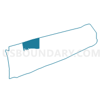
Outline

Summary
| Unique Area Identifier | 637152 |
| Name | Voting District 0200000 |
| County | Suffolk County |
| State | New York |
| Area (square miles) | 130.01 |
| Land Area (square miles) | 0.00 |
| Water Area (square miles) | 130.01 |
| % of Land Area | 0.00 |
| % of Water Area | 100.00 |
| Latitude of the Internal Point | 41.02407170 |
| Longtitude of the Internal Point | -73.00271250 |
Maps


Graphs
Select a template below for downloading or customizing gragh for Voting District 0200000, Suffolk County, New York


Neighbors
Neighoring Voting District (by Name) Neighboring Voting District on the Map
- Voting District 0200002, Suffolk County, NY
- Voting District 0200004, Suffolk County, NY
- Voting District 0200005, Suffolk County, NY
- Voting District 0200008, Suffolk County, NY
- Voting District 0200035 0200047, Suffolk County, NY
- Voting District 0200061, Suffolk County, NY
- Voting District 0200086, Suffolk County, NY
- Voting District 0200093, Suffolk County, NY
- Voting District 0200117, Suffolk County, NY
- Voting District 0200136 0200188 0200195, Suffolk County, NY
- Voting District 0200148, Suffolk County, NY
- Voting District 0200153, Suffolk County, NY
- Voting District 0200177, Suffolk County, NY
- Voting District 0200187, Suffolk County, NY
- Voting District 0200189, Suffolk County, NY
- Voting District 0200190, Suffolk County, NY
- Voting District 0200220, Suffolk County, NY
- Voting District 0200224, Suffolk County, NY
- Voting District 0200225, Suffolk County, NY
- Voting District 0200233, Suffolk County, NY
- Voting District 0600000, Suffolk County, NY
- Voting District 0600001, Suffolk County, NY
- Voting District 0800000, Suffolk County, NY
- Voting District 0800056, Suffolk County, NY
- Voting Districts not defined, Fairfield County, CT
- Voting Districts not defined, New Haven County, CT
Top 10 Neighboring County Subdivision (by Population) Neighboring County Subdivision on the Map
- Brookhaven town, Suffolk County, NY (486,040)
- Smithtown town, Suffolk County, NY (117,801)
- Riverhead town, Suffolk County, NY (33,506)
- County subdivisions not defined, Fairfield County, CT (0)
- County subdivisions not defined, New Haven County, CT (0)
Top 10 Neighboring Place (by Population) Neighboring Place on the Map
- Setauket-East Setauket CDP, NY (15,477)
- Rocky Point CDP, NY (14,014)
- Stony Brook CDP, NY (13,740)
- Miller Place CDP, NY (12,339)
- Mount Sinai CDP, NY (12,118)
- Port Jefferson village, NY (7,750)
- Wading River CDP, NY (7,719)
- Sound Beach CDP, NY (7,612)
- East Shoreham CDP, NY (6,666)
- Poquott village, NY (953)
Top 10 Neighboring Unified School District (by Population) Neighboring Unified School District on the Map
- Smithtown Central School District, NY (57,142)
- Three Village Central School District, NY (48,424)
- Riverhead Central School District, NY (38,457)
- Rocky Point Union Free School District, NY (17,907)
- Miller Place Union Free School District, NY (15,859)
- Mount Sinai Union Free School District, NY (12,985)
- Shoreham-Wading River Central School District, NY (12,878)
- Port Jefferson Union Free School District, NY (7,570)
- School District Not Defined (Water), CT (0)
Top 10 Neighboring State Legislative District Lower Chamber (by Population) Neighboring State Legislative District Lower Chamber on the Map
- Assembly District 1, NY (149,382)
- Assembly District 4, NY (137,024)
- Assembly District 7, NY (134,480)
- State House Districts not defined, CT (0)
Top 10 Neighboring State Legislative District Upper Chamber (by Population) Neighboring State Legislative District Upper Chamber on the Map
- State Senate District 1, NY (341,254)
- State Senate District 2, NY (314,159)
- State Senate Districts not defined, CT (0)
Top 10 Neighboring 111th Congressional District (by Population) Neighboring 111th Congressional District on the Map
Top 10 Neighboring Census Tract (by Population) Neighboring Census Tract on the Map
- Census Tract 1697.01, Suffolk County, NY (7,719)
- Census Tract 1583.04, Suffolk County, NY (6,941)
- Census Tract 1580.02, Suffolk County, NY (6,315)
- Census Tract 1584.07, Suffolk County, NY (5,963)
- Census Tract 1583.17, Suffolk County, NY (5,815)
- Census Tract 1580.01, Suffolk County, NY (4,770)
- Census Tract 1582.07, Suffolk County, NY (4,770)
- Census Tract 1584.02, Suffolk County, NY (4,481)
- Census Tract 1584.08, Suffolk County, NY (4,025)
- Census Tract 1582.06, Suffolk County, NY (3,772)
Top 10 Neighboring 5-Digit ZIP Code Tabulation Area (by Population) Neighboring 5-Digit ZIP Code Tabulation Area on the Map
- 11733, NY (18,949)
- 11790, NY (18,511)
- 11780, NY (15,524)
- 11764, NY (13,200)
- 11778, NY (12,709)
- 11766, NY (12,635)
- 11777, NY (8,968)
- 11792, NY (8,523)
- 11789, NY (7,895)
- 11786, NY (6,344)